Science at sea
May 22nd, 2007We’ve had a couple of breaks in our journey over the last few days to do some scientific work. Uta Neumann from the University of Kiel joined the ship in Montevideo in order to recover some instruments in the Vema Channel (also known as the Rio Grande Gap), which is a gap in a range of undersea mountains, almost exactly due east of the city of Rio Grande in Brazil (which, coincidentally is the nearest city to Cassino). The region is interesting because warm waters from the tropics pass through the gap into colder waters from further south. Anyway, Uta’s colleagues have had a set of instruments attached to a “mooring” for the last two years – it’s a long cable anchored to the seabed with instruments and buoys attached to it at regular intervals. When it’s time to collect the instruments, the ship sends a coded command to the mooring as a sound signal through the water, and the cable detaches from the anchor and the instruments float to the surface. It takes about an hour for the mooring to come up – they’re a long way down! Once the mooring is sighted (not always easy – occasionally instruments are lost because they get swept away by currents as they come to the surface) the ship’s crew grapple the mooring and pull it on deck.

Recovering the mooring

Uta and one of the instruments – the yellow blobs are the buoys that brought it to the surface
On this mooring the instruments were making oceanographic measurements – measuring the speed and direction of the currents and the temperature and salinity of the water. To check the data, the instruments (after being downloaded) were lowered into the water on the ship’s CTD instrument (which also measures temperature and salinity) and the data will be compared to make sure that the instruments are still calibrated after two years in the South Atlantic.
Doing a CTD on the ship is like doing one at Rothera, but on a much bigger scale – a large gantry unfolds from the starboard side and the instrument is winched down to the bottom and then back up again. Unlike the one at Rothera you get a real-time readout of the data from the instrument, and the winch is power operated, which is just as well as the sea was over 4000m deep at the site.
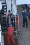
The CTD instrument being swung out across the deck

The gantry swings down and lowers the instrument into the water
You can follow the ship’s progress using the magic of Sailwx.info, which uses the ship’s regular weather reports to plot its position.
May 22nd, 2007 at 1:06 pm
Very clean instruments and moorings after 2 years in the sea. There can’t be much that likes to inhabit hard surfaces at 4000m – not like around UK waters where everything gets covered in mussels, tube worms, hydoids, algae … and gets corroded as well. Pretty civilised weather & sea conditions for mooring recovery too – a good place to do oceanography!